|
Distance: 15 miles/23km
Route: Prestbury Railway Station - Hare Hill - Mottram St Andrew - Adlington Railway Station - Clark Green - Whiteley Green - Prestbury Railway Station
Surface: Tarmac
Start: Prestbury Railway Station
Map: OS Landranger 109 (Manchester and surrounding area) and OS 118 (the Potteries)
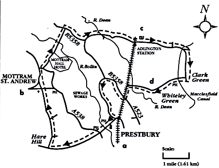
Leave Prestbury Railway Station and turn left.
Follow the road down over the River Bollin and continue through Prestbury Village to a small roundabout.
Take the road on your right and continue up to Chelford Road.
Turn left and cycle up the hill for around two miles until you reach Oak Road. Head down Oak Road for a further two miles.
At the end of Oak Road you reach Mottram St Andrew. Turn right here and immediately left down Moss Lane. Follow this road up to the junction, where you turn right and follow the road to the bottom.
Soon you reach the A538, where you turn right.
Take your next left turn - Mill Lane, going round the back of Mottram Hall Hotel (on your right).
You soon go over the River Bollin and then up to a crossroads. Turn right here onto Wilmslow Road (B5358) and take a left fork down another Mill Lane.
Follow this road over the River Dean and pass Adlington Hall on your right until you reach another set of crossroads with the Legh Arms Pub directly opposite.
Cross over the road (A523) onto Brookledge Lane and pass Adlington Railway Station on your right.
Follow Brookledge Lane, cycle past Adlington Primary School and go over the Middlewood Way (a disused railway line).
After crossing the Macclesfield Canal, take the next right down Sugar Lane and cycle for about a mile until you reach Holehouse Lane.
Turn right here and continue over the canal and Middlewood Way once again.
Go downhill past the Windmill Pub on your left. Follow Holehouse Lane over the River Dean before you reach the A523.
Turn left here onto the main road and turn right onto Bovis Halle Lane.
Go under the railway ridge and then take the next left down Butley Lanes. This leads to a T-junction opposite Prestbury Railway Station once again past the sewage works on the right.
|